Earth Surface Shaping by Biota, EarthShape Project, a German-Chilean Initiative
Part II of our collaboration with the South American Mycorrhizal Network, please read part one here.
EarthShape project team, Pan de Azúcar National Park, Atacama Desert, Chile. Credit: Leandro Paulino
The EarthShape project is currently the biggest collaboration effort between Germany and Chile. The overarching research question of this project is how microorganisms, animals, and plants influence the shape and development of the Earth’s surface over time scales from the present-day to the distant geologic past. This multidisciplinary research project is developed in the Chilean Coastal Range, in a network of long-term ecological studies sites via the German Priority Program DFG 1803, and involves up to 60 researchers from Germany and 20 from Chile, besides numerous posdoctoral fellows and graduate students from both countries. The project is led by Prof. Dr. Todd A. Ehlers, from the Department of Geosciences, University of Tübingen, Germany, and Prof. Dr. Friedhelm von Blanckenburg from the Helmholtz Research Center in Potsdam, German Research Center (‘GFZ’), Germany, and Dr. Kisrtin Übernickel, Department of Geosciences, University of Tübingen, Germany, as executive director.
The EarthShape project has established a strong collaboration with leading Chilean professors, researchers, and their funding agents and institutions. These researchers work in all of the disciplines essential to the project integration, including biogeochemistry, geochemistry, microbiology, geomorphology, tectonics, sedimentology, soil science, hydrology, and geophysics. The Chilean colleagues are interested in collaborating with participants, and assisting in fieldwork, logistics, and provide access to Chilean sites, which are protected areas.
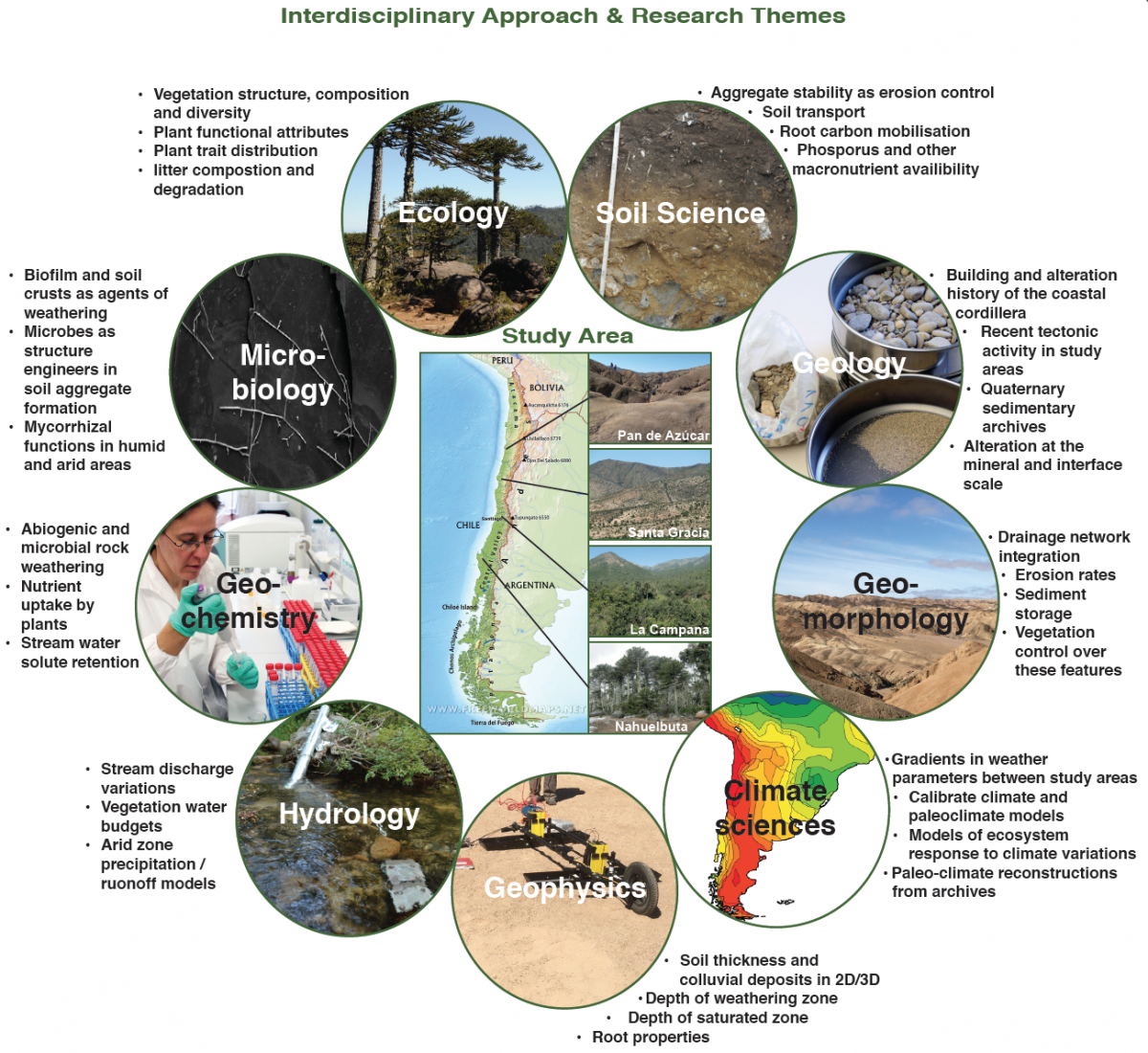
Research themes of the EarthShape Project
All the study sites are located in the Coastal Cordillera of Chile. These sites span from the Atacama Desert in the north, one of the dryest places on Earth, to the very rainy Araucaria araucana forests approximately 1300 km to the south. The site selection contains a large ecological and climate gradient ranging from very dry to humid climate conditions. The sites were selected to avoid other complicating factors such as differences in rock type, and glacial, and volcanic impacts.
Left: exploring rocks at Pan de Azúcar National Park, Atacama Desert, Chile;
Right: Araucaria forest, Nahuelbuta National Park, Chile. Credit: Leandro Paulino and César Marín
This proposal is essential for the development of new knowledge and the formation of advanced human capital in the region. It also helps to understand, predict, and mitigate the impacts of environmental change processes (anthropogenic and natural) that are developed through several spatio-temporal scales.
Geological excavation, Pan de Azúcar National Park, Atacama Desert, Chile. Credit: Leandro Paulino
In addition, at the regional or Chilean level, the sites of this network of natural observatories can provide baselines of the state of ecosystems, and answer questions relevant to the sustainability and future potential of many productive activities in the country in the long term. These sites in National Parks of Chile, to the extent that they are implemented and used as areas of reference and experimentation by researchers, allow the realization of comparative studies and the evaluation of models and ecological theories in a framework that promotes communication between researchers and society, thus favoring the valuation and protection of the Environment. These baseline studies have already produce some results, including mycorrhizal fungi (Bueno et al. 2017) , Cercozoan protists (Fiore-Donno et al. 2018), and biological soil crusts (Lehnert et al. 2018).
The EarthShape project is coordinated in Chile by the executive director Dr. Leandro Paulino, University of Concepción (Chillán headquarters) and Dr. Roberto Godoy, Austral University of Chile.


